Earliest meeting: Wednesday 6th October 1824
Final meeting: Friday 7th October 1853
Rugeley is an historic Staffordshire market town on the edge of Cannock Chase. The earliest record of racing taking place in the town was a 3 day meeting from Wednesday 6th to Friday 8th October 1824 on a course at the Training Ground on Wolseley Park near Etching Hill, when the Rugely Sweepstakes was won by the magnificently named Ynysymaengwyn owned by Mr Massey. However, it was a further 9 years before results were included in Baily's Racing Register from the 1833 meeting. That 2 day meeting was staged on Thursday 26th and Friday 27th September 1833; the principal Rugeley Stakes went to Mr Painter’s Mezereon who beat Sylph. Meetings continued for a further 20 years until a final card on Friday 7th October 1853, with the final race being won by William Palmer, the Rugeley Poisoner. However, there remains a mystery first raised by John Griffiths, author of the excellent books on Hednesford and Walsall races. The mystery concerns the oval shape of the course between 1824 and 1853, and the figure-eight shape in the early part of the 20th century. When did the change take place?
To provide an answer to this question the following evidence is presented:-
EXHIBIT A: The newspaper report of the inaugural meeting;
EXHIBIT B: Evidence from two further early meetings;
EXHIBIT C: The 1834 map;
EXHIBIT D: The 1873 map;
EXHIBIT E: Map of Rugeley racecourse from 1902;
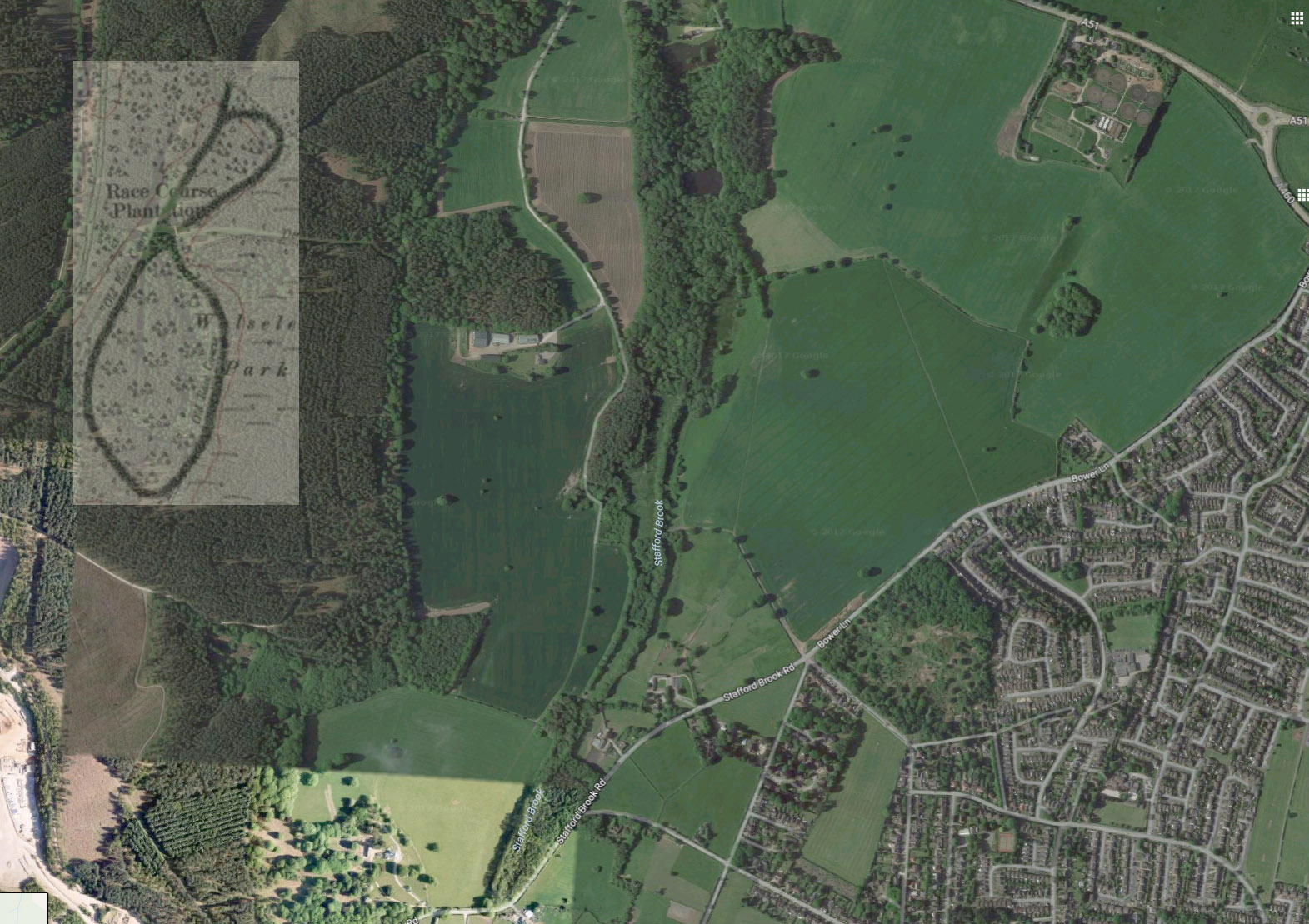
EXHIBIT F: Map of the figure 8 course superimposed on a present day map.
EXHIBIT A: The newspaper report of the inaugural 2 day meeting in 1824 is shown courtesy of the Staffordshire Advertiser and British Library Online. Race distances were 'twice round the course' implying it was more likely to be an oval rather than 'circuits' of a figure 8 course.
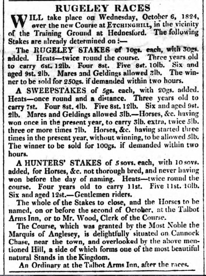
Rugeley Stakes over 2 miles
1. Patshull owned by Sir G Pigot
2. Orator owned by Mr Yates
3. Unnamed colt by Cato owned by Mr Haynes
Rugeley Hunters Stakes over 2 miles
1. The Letterman owned by Mr Wakefield
Rugeley 5 Guineas Sweepstake over a mile and a furlong
1. Ynysymaengwyn owned by Mr Massey
2. Sarasparilla owned by Mr Painter
3. Niobe owned by Mr Flintoff
EXHIBIT B: The newspaper extract of the 1826 meeting is shown courtesy of the Derby Mercury of 11/10/1826 and continues to mention distances more akin to an oval course than a figure 8 course.
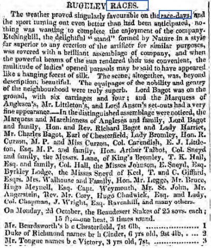
The newspaper report of the 1827 meeting is shown courtesy of the Warwick Advertiser 1/9/1827
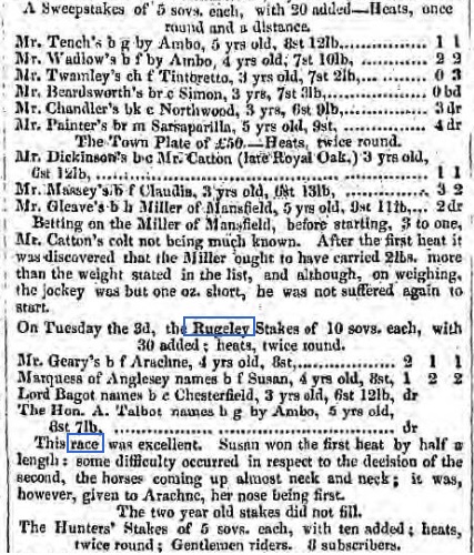
Thursday 26th to Friday 27th September 1833
Rugeley Sweepstakes over 1 mile and a distance
1. Decoction owned by Mr Painter
Rugeley Stakes over 2 miles
1. Mezereon owned by Mr Painter
2. Sylph owned by Mr E.Peel
3. Derby owned by Mr Beardsworth
EXHIBIT C: I am grateful to Ordnance Survey (© Crown Copyright) for permission to use the 1834 map shown below. It clearly shows an oval course.
.jpg)
Wednesday 31st May & Thursday 1st June 1837
The Beaudesert Stakes over 2 miles
1. Pelops owned by Lord Warwick
2. Heron owned by Mr Fowler
3. Wolverhampton owned by Mr Critchley
Rugeley Handicap Stakes over 2 miles
1. Morel owned by Captain Lamb
2. Bucephalus owned by Mr Walters
3. Rasper owned by Mr Lager
Rugeley Free Handicap Stakes over a mile
1. Sir Felix owned by Mr Walter
2. Unnamed filly by The Colonel owned by Lord Warwick
3. Misprint owned by Mr Berrington
The final race on the final day, Friday 7th October 1853, before Rugeley races were confined to history, was the Anglesey Stakes, over two and a quarter miles, in which William Palmer, the Rugeley Poisoner, saddled the appropriately named Doubt.
To read a detailed history of the Rugeley Poisoner CLICK HERE
The Anglesey Stakes over 2 ¼ miles
1. Doubt (4/5 fav), bay mare owned by Mr William Palmer and ridden by Wells
2. Ethelwolf, brown colt owned by Mr Oliver and ridden by Wakefield
3. Liberty, brown gelding owned by Mr Adey and ridden by Tom Ashmall
4. Roger Thornton, black colt owned by Mr Bennyon and ridden by Lee
5. Morning Star, bay colt owned by Mr Shelmerdine and ridden by Wilson
The final meeting took place on Friday 7th October 1853.
EXHIBIT D: A map, supplied by John Griffiths, showing Rugeley racecourse at the time of military manoeuvres that took place in the area in 1873, confirming it was still an oval course with no signs of a figure of eight.
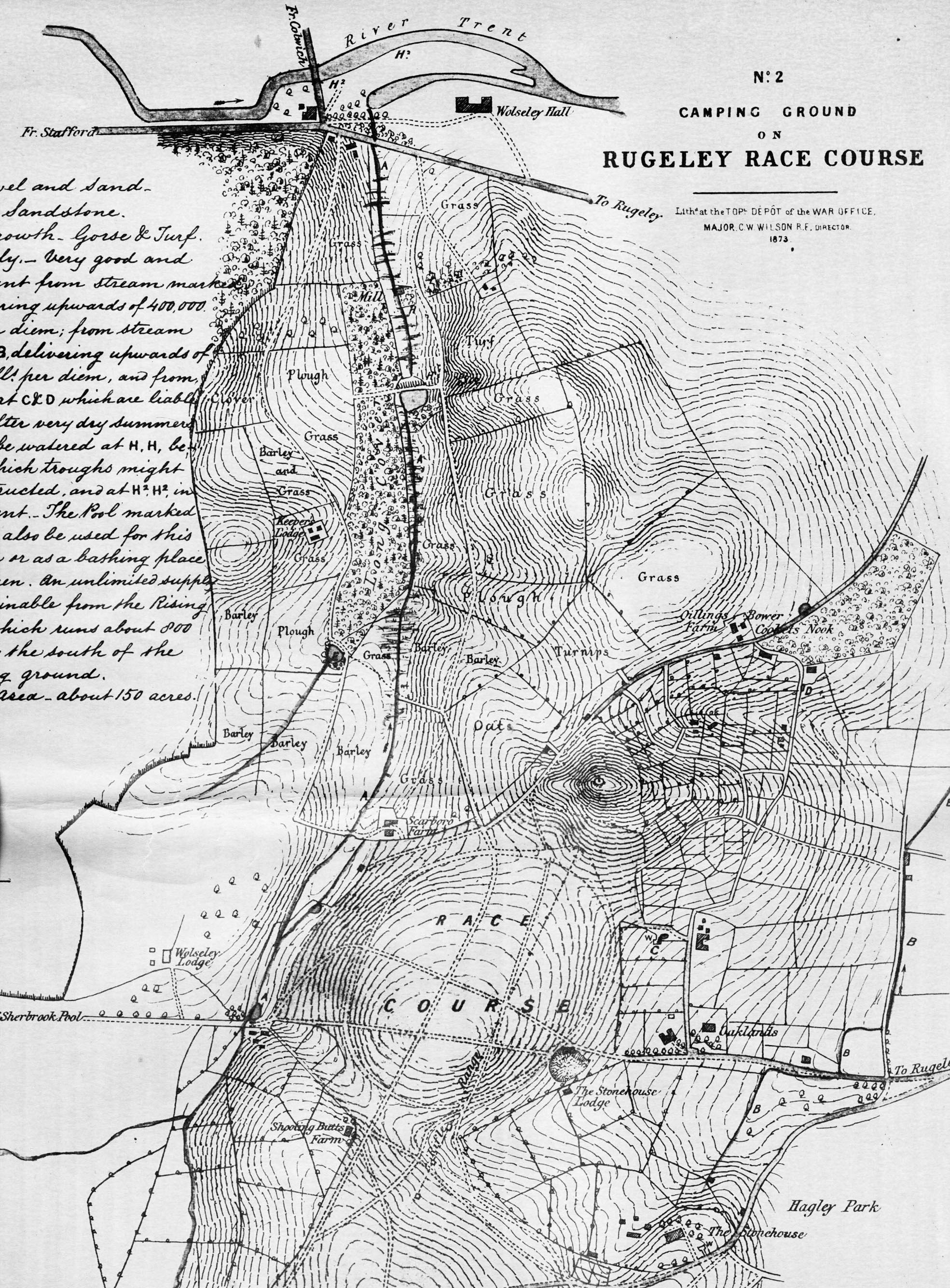
EXHIBIT E: The 1902 map shown below is the first to indicate a figure of 8 course.
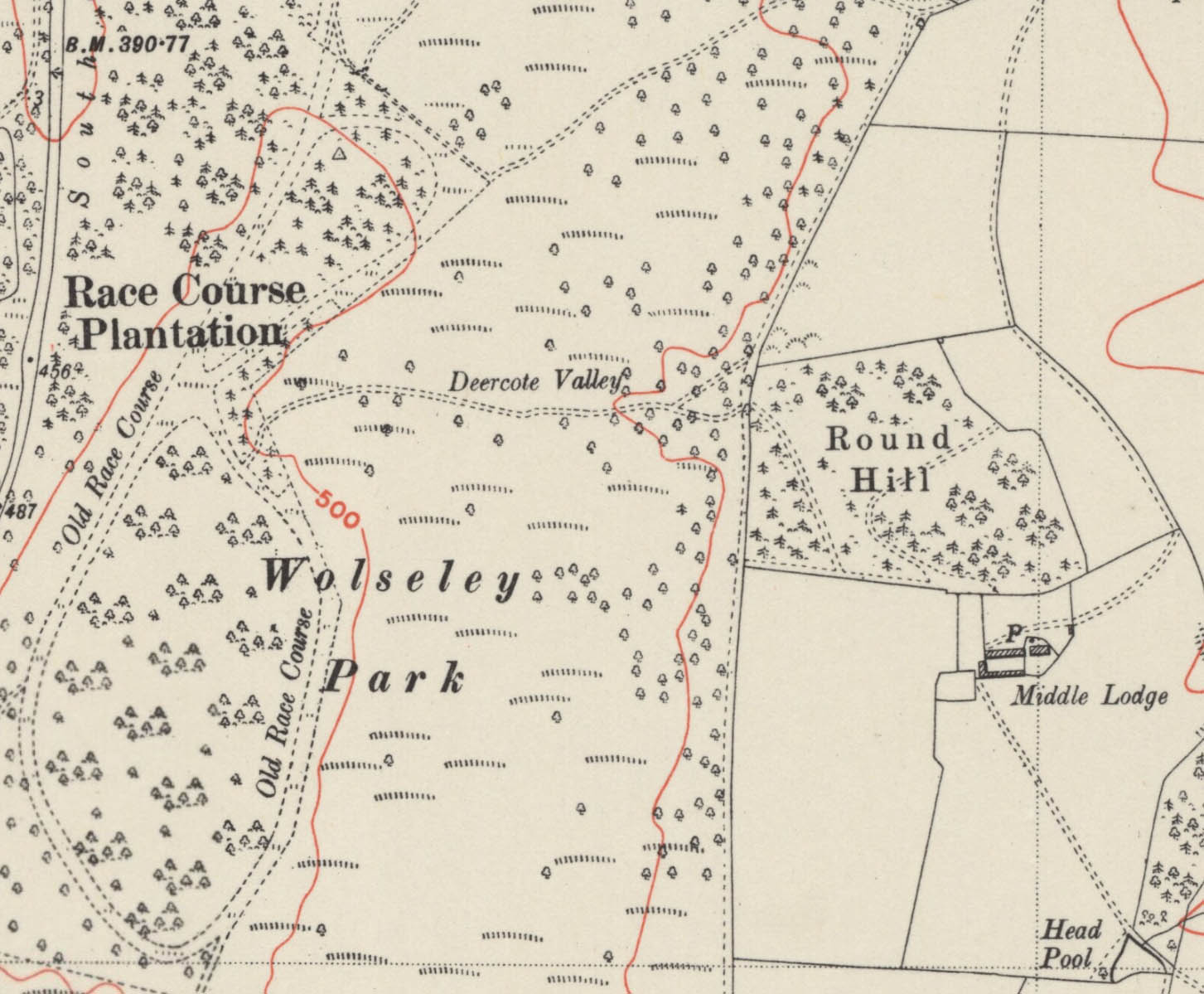
EXHIBIT F: John Griffiths has supplied a current day map (© 2017 Google) which shows the position of the figure of 8 course.
I am grateful to Carl Mason for the research work he carried out in February 2018 on Rugeley Races to try to address some of the points made above, in particular on the shape and location of the course. He has agreed to allow his findings to be included on the website and they are shown in full below:-
‘It seems that there is some confusion regarding both the shape of the course and its exact location. I have studied old maps and compared map details, features and topography with the current (2015) OS map and my conclusion is that the old oval course shown on old maps and the evidence for a figure of 8 course relate to 2 different locations, although they are in close proximity.
When looking at maps, the oval course is clearly placed slightly above and to the right of Shooting Butts Farm and slightly to the right and below Scarboro Farm, with Etching Hill placed to the top right.
Paths, roads and other map details eg buildings, can be traced and clearly identified when comparing old maps with the current ones. It is hard to dispute that the race course of 1824 - 1873 was oval in shape and was located firmly at Etching Hill.
Further support of this location is obtained from a publication by Cannock Chase Council - "Discovery Walks - Western Springs, Pump Lane and Etching Hill" - in which it states that it is known that in the 1820's a horse race circuit looped around the Hill. Indeed it is also stated that "Etching" is derived from "Hitching" the practice of tethering horses to posts. In fact on the 1834 map the location is named as "Hitching Hill" not "Etching Hill"
The 1873 map (Exhibit D) appears to very accurate in its placement of the oval course.
I suspect that this course was always oval and was never altered to a figure of 8. Nevertheless it is quite feasible that the location of the oval, being just below the Etching Hill, may have at one time included at its upper end a second oval that "looped around the Hill" making a figure of 8, but this is purely conjecture. Perhaps the original course was around the Hill and not in front of it, and for a time was retained as a figure of 8 after the construction of the new oval course in front of the Hill.
None of this explains the references to a figure of 8 course in the Wolseley Park location.
Your Exhibits E and F (the figure of 8 course) are clearly placed in an area known as Wolseley Park, This area is to the North and West of Etching Hill, to the left of Round Hill and not far from the Oval course. Current maps show an area within this location named as "Racecourse Plantation" suggesting that there was a racecourse there, (or has it simply been named so, because there was a racecourse nearby)?
I note that on the Exhibit E map, the wording "old race course" is also shown.
The question is, given that maps of 1834 and 1873, combined with other evidence, show the old Oval racecourse to have been at Etching Hill, when was the Wolseley Park figure of 8 location in use and indeed what was it used for?
Did it Pre-date 1820?
(The 1824 Newspaper clipping does refer to "the New Course at Etchinghill" But then the Walks Leaflet states that a horse race circuit looped around the Hill in the 1820's, whereas the maps show the course to be in front of the Hill - was this a change that created "the New Course"?)
Was it used exclusively by the incumbents of Wolseley Hall a short distance to the North?
Did it succeed the Etching Hill course? (This seems unlikely, and no records can be found of races pre-1824)
Was it ever a "racecourse" or was it a training and exercise location?
Or was the area wrongly identified as a racecourse site and incorrectly recorded on some publications?
As is often the case, some questions answered invite new questions to be asked, but it seems that there are more questions concerning the Wolseley Park location than there are about the Rugeley Race Course at Etching Hill.’
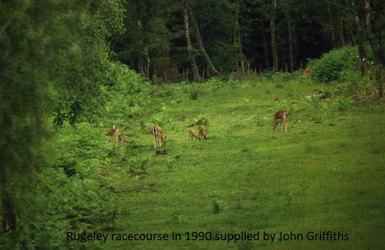
The photograph of Rugeley Racecourse shown below is courtesy of John Griffiths.
If you have photos, postcards, racecards. badges, newspaper cuttings or book references about the old course, or can provide a photo of how the ground on which the old racecourse stood looks today, then email johnwslusar@gmail.com
Much of the information about this course has been found using internet research and is in the public domain. However, useful research sources have been:-
London Illustrated News
Racing Illustrated 1895-1899
The Sporting & Dramatic Illustrated
Northern Turf History Volumes 1-4 by J.Fairfax-Blakeborough
The Sporting Magazine
A Long Time Gone by Chris Pitt first published in 1996 ISBN 0 900599 89 8
Racing Calendars which were first published in 1727